

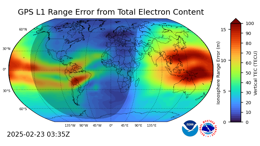


The ionosphere is a layer of Earth’s atmosphere that starts around 80 kilometers above the surface and extends up to about 600 kilometers. In this region, the Sun’s strong ultraviolet (UV) and X-ray light knocks electrons away from atoms and molecules, creating a layer filled with electrically charged particles. Changes in the ionosphere can bend or reflect radio waves, which affects communication signals in multiple frequencies. The Total Electron Content (TEC) is a way to measure how many of these charged particles (electrons) lie between a radio transmitter and a receiver. If there are a lot of electrons along the path, the radio signals can slow down or change direction, causing errors in navigation or communication systems. More information on how TEC impact GPS system can be found here.
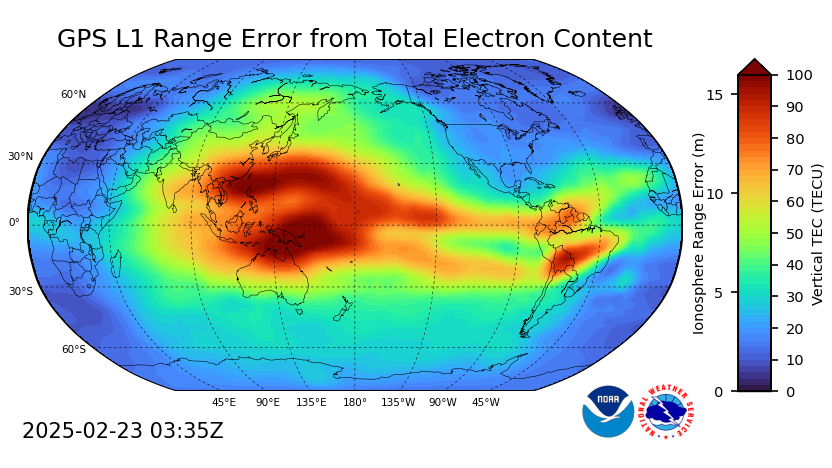
The Global Total Electron Content (GloTEC) model provides ionosphere situational awareness for users with systems affected by trans-ionospheric radio frequency propagation such as Global Navigation Satellite System (GNSS) and satellite communications. The Total Electron Content (TEC) maps can be used to estimate the GNSS signal delay due to the ionospheric plasma between a receiver and a GNSS satellite. This delay impacts GNSS positioning and timing accuracy, especially during geomagnetic storms.
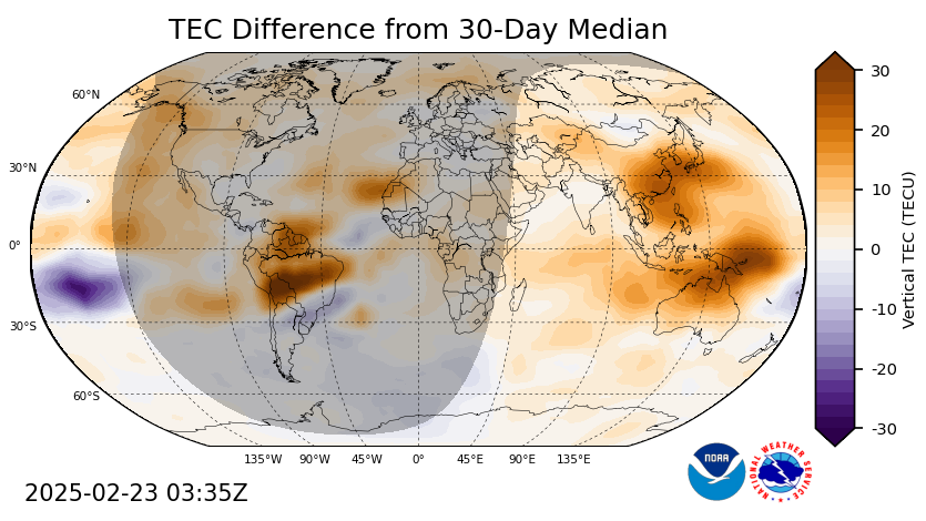
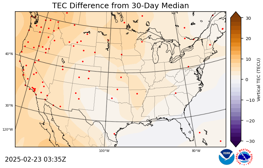
Plots of global TEC, anomaly (deviation from the 30-day median), and observational counts are displayed on the website. Regional plots for the CONtinental US (CONUS) and North America can be found in the tabs at the top of the page. GNSS sites used in the current assimilation cycle are shown as the red dots in the regional plots. TECU is the unit for TEC, where 1 TECU equals 1016 electrons per square meter.
The GloTEC is a data-assimilative model. Therefore, model results at the locations where observations are ingested are most trustworthy. Where there are no observations, the TEC tends to relax to IRI-2016 climatology driven by the measured F10.7 index. The Average F-region Observation plot and the quality_flag variable in the NetCDF data files provide information on the number of observations ingested into the model. Real-time global TEC and other data can be downloaded in NetCDF and JSON formats through the link under the “Data” tab.
GloTEC is a global 3-dimensional data assimilation system that uses a Gauss-Markov Kalman Filter to optimally estimate electron density in the ionosphere. The system ingests slant Total Electron Content (sTEC) from the ground-based GNSS receivers as well as space-based Radio Occultation (RO) sTEC from the COSMIC-2/FORMOSAT-7 constellation. International Reference Ionosphere 2016 (IRI-2016) driven by the real-time F10.7 index is used as a background model both as an a-prior state and to propagate the state forward between assimilation.
Ground-based GNSS observations used in GloTEC come from several data providers listed below:
-
International GNSS Service (IGS)
-
University NAVSTAR Consortium (UNAVCO)
-
Crustal Dynamics Data Information System (CDDIS)
-
Natural Resources Canada (NRCan)
-
Geoscience Australia Continuously Operating Reference Stations (AUSCORS)
-
Instituto Brasileiro de Geografia e Estatística (IBGE)
-
Red Argentina de Monitoreo Satelital Continuo (RAMSAC)
The default GloTEC horizontal grid resolution is 2.5° in latitude and 5° in longitude with a variable vertical grid resolution (20km from 80-450km, and then an increasing grid spacing from 450km to 8500km).
Ground-Based Input Files:
-
International GNSS Service (IGS) - https://igs.org/rts
-
University NAVSTAR Consortium (UNAVCO) - https://www.unavco.org/data/gps-gnss/real-time/real-time.html
-
Crustal Dynamics Data Information System (CDDIS) - https://cddis.nasa.gov/Data_and_Derived_Products/GNSS/real-time_data.html
-
Natural Resources Canada (NRCan) - https://webapp.csrs-scrs.nrcan-rncan.gc.ca/geod/data-donnees/rtk.php
-
Geoscience Australia Continuously Operating Reference Stations (AUSCORS) - https://gnss.ga.gov.au/stream
-
Instituto Brasileiro de Geografia e Estatística (IBGE) -https://www.ibge.gov.br/geociencias/informacoes-sobre-posicionamento-geodesico/servicos-para-posicionamento-geodesico/16332-rbmc-ip-rede-brasileira-de-monitoramento-continuo-dos-sistemas-gnss-em-tempo-real.html
-
Red Argentina de Monitoreo Satelital Continuo (RAMSAC) - https://www.ign.gob.ar/NuestrasActividades/Geodesia/Ramsac
Space-Based Input Files:
-
University Center for Atmospheric Research (UCAR) COSMIC-2 - https://www.cosmic.ucar.edu/what-we-do/cosmic-2/data
GloTEC conference abstract: https://ui.adsabs.harvard.edu/abs/2022cosp...44.3472F/abstract
Fuller-Rowell, D., Fang, T.W., Steenburgh, R. and Fuller-Rowell, T., 2022. Observation-and Model-driven GNSS related products at SWPC and plans for the future. 44th COSPAR Scientific Assembly. Held 16-24 July, 44, p.3472.
Comparison to other ionosphere models: https://agupubs.onlinelibrary.wiley.com/doi/full/10.1029/2023SW003480
Chou, M.Y., Yue, J., Wang, J., Huba, J.D., El Alaoui, M., Kuznetsova, M.M., Rastätter, L., Shim, J.S., Fang, T.W., Meng, X. and Fuller‐Rowell, D., 2023. Validation of ionospheric modeled TEC in the equatorial ionosphere during the 2013 March and 2021 November geomagnetic storms. Space Weather, 21(6), p.e2023SW003480.
OSSE validation of forward model: https://ieeexplore.ieee.org/abstract/document/6587745
Yue, X., Schreiner, W.S., Kuo, Y.H., Braun, J.J., Lin, Y.C. and Wan, W., 2013. Observing system simulation experiment study on imaging the ionosphere by assimilating observations from ground GNSS, LEO-based radio occultation and ocean reflection, and cross link. IEEE Transactions on Geoscience and Remote Sensing, 52(7), pp.3759-3773.
GloTEC Output Files:
GloTEC Archive:
NetCDF data files:
The NetCDF files have dimension variables for latitude, longitude, and time, as well as data variables for TEC and quality_flag. The quality_flag variable is calculated by taking the mean number of F-region observations in each vertical profile and rounding up to the next integer except when larger than five. When the mean number of observations are larger than five, the quality_flag is rounded down to five.